I have dreams of finishing the trail, only half-remembered on waking. That’s probably to do with the windstorm howling outside, punctuated by some kind of precipitation – kinda gets your attention, particularly when you know you have to get out into it, make it about 20 miles to your resupply before the place closes. Still, it’s 5:30, and I’m not going out into that if I don’t have to, even if I know it’s going to be light enough to hike by 6:30. I’m not terribly interested in hiking through this.
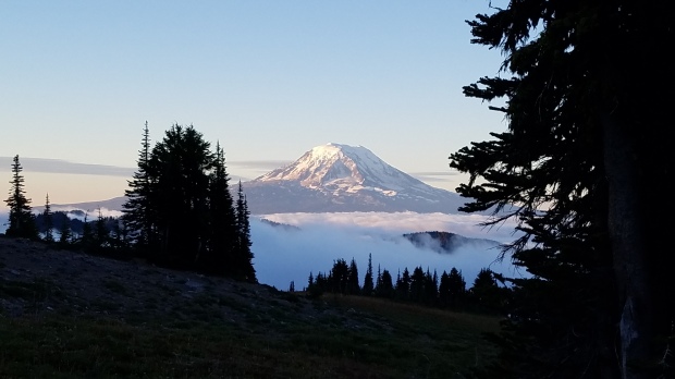
Things chill out after a while; the precipitation stops, so I’m up and packing and cooking by 6, monitoring my couscous to make sure a stray gust doesn’t put my stove out. I shovel the food in and scurry out to stow my tent, find the clouds are coming for me – nuuuuu the Knife’s Edge is supposed to be the prettiest part of the traaaail clouds whyyyyyy. I don’t think I’ve ever packed my tent so fast, and while I take pictures from my site I haul out of there, clouds close at my heels.
I’ve got two options today. If it looks like a storm’s going to roll in, the safe bet is to take the Stock Route that bypasses what is supposedly the prettiest part of the Knife’s Edge. If it looks safe enough, I can climb higher, walk what is, even in sunlight, one of the most exposed parts of trail the PCT covers.
As I’m climbing towards a decision, it seems the clouds are staying at a certain height – and after seeing that the stock route is sketchy, too, and has a concerning-looking snowfield in one part, my decision’s made – I’m going for it.
So it’s up I go, up switchbacks, alternately facing Adams and, when I get high enough, Rainier:
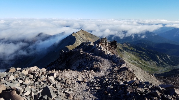
And then, I hit the top:
Daaang. It’s gorgeous up here.

That is, indeed, the path heading off to the right. I’m sheltering in the lee of the rock to the left.
I wish I could see more, but the clouds kind of feel right, make things a little more majestic. I hang out up top until the urge to walk is too strong, and then I step out of the lee of the rock and holyshitcold. The wind is howling, and my fingers are rapidly becoming useless, but I still can’t help but stop and take pictures every few steps. The land is that captivating.
It’s all shale up here, and it’s indeed as exposed as I’ve been told – I hear Ambulance’s voice in my head from yesterday, saying that two people have fallen in the last week. I try to make sure of my steps, but I slip, catch myself, but turn my left ankle in the process. Well, I guess I see how. I’m standing, catching my breath, let my heart know it can keep beating. I note in a distant kind of way that I was way less wary of heights before I climbed Half Dome.

I rejoin the stock trail and learn that there’s more Knife’s Edge down here, more views to be had. It seems like the sun is giving me a tour of the landscape by burning off only certain sections of cloud at a time, lighting up the places I’m headed as I approach them. It makes for a pretty magical morning.
And then just like that, it’s over, no more exposure, and I’m shrouded in cloud at the Coyote Trail Junction. There are nice hikers there – Jim, Jeff, Aimee, and Tika the pupper, who take a break from their climb up the Coyote Trail to chat with me. They ask me if I’ve seen a couple of hikers, but they only know their frontcountry names, and it’s been a while since I’ve heard a thru use one of those. We fall into easy conversation anyway – Jim’s done a lot of hiking around Washington, and he raves about Stehekin to me, and I get even more excited about the trail town, if that’s possible. Eventually I realize that I’ve made three miles in three hours – WHOOPS – and I excuse myself. Gotta make those miles.
The clouds start to clear as I round a corner, head down towards the first water of the morning. Dart catches me as I get there, and then, there’s MAGA – I let him go in front of me, but I’m faster than him today, so it seems this is the perfect opportunity to talk to him about his preferred candidate. I engage in good faith – asking questions rather than making assumptions, letting him tell me what he thinks instead of telling him what he stands for – and I come out of the conversation more confused than before. Basically, MAGA thinks that Trump is either exaggerating or speaking in metaphor or flat-out lying – which is fine, apparently. He won’t actually put Muslims into a registry or build a wall on the southern border or put women in jail for abortions. He won’t be able to get any of his crazier ideas through Congress. I wish I had his confidence. I’m on the verge of pressing that point home when Dart joins us, keeps derailing the conversation by making other points to the point of talking over me. I guess we’re done with that for now.
The conversation turns to a heated talk about the differences between graffiti in cities and graffiti in nature, and we’re on a 3-mile, 2000-foot climb, and I’m annoyed that I didn’t finish the conversation with MAGA, so I decide to take a break, letting the gents get well ahead of me. Eating makes me feel better, though I still feel a little empty when I’m done. I don’t know if I’ll ever see MAGA again, let alone get to the point where I can start making points I want to make in a way that might make him think. But that’s life, I guess.
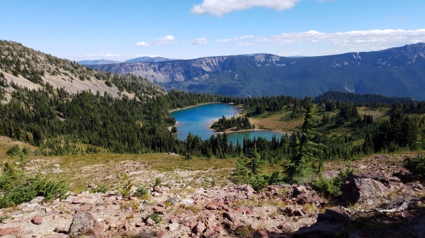
At the top, I can see Rainier again, but I can also see Shoe Lake, which I travel alongside for a while and which also does not look like a shoe:
Then it’s around a corner to sidehill it for a while:

Then it’s down, down beside a ski hill, weaving in and out of the Goat Rocks Wilderness before we’re out for good. The down is so down it hurts, and I’m thankful when it finally starts switchbacking.
Close to the road, there’s a family coming up the trail – two adults, two dogs, two children, and a tiny human strapped to one of the adults. They ask me if the trail we’re on is a loop, or if it can be made into one; I tell them I don’t really know much about the area. They seem confused – I guess I smell look like I know what I’m doing – and ask me how far this trail goes. Weeell, I came from Mexico, soooo… probably farther than you’re looking to go this evening. They look incredulous, but don’t ask any follow-up questions; maybe they think I’m joking. I tell them about the nice stream at the end of a switchback probably a quarter of a mile up the hill. That’s probably a good place to stop. They thank me, and I continue down the hill to the parking lot and the Pass proper.
It’s a bit of a walk down the road to the Kracker Barrel – a gas station that accepts packages, has a place for hikers to sit and charge things, has food to munch. The lady tells me they’re closing in an hour OH NO MUST DO ALL OF THE THINGS. Charging, eating food out of the case, endearing myself to the woman behind the counter with tactful self-deprecation, food repackaging, buying more fuel, almost microwaving a frozen burrito with aluminum foil1, utilizing the flush toilet, doing town chores – all of this is packed into an hour. Then we get shooed out, though not shooed away – I’m trying to put off walking back to the trail, so I chat with the other hikers, particularly Mama Lion and her 9-year-old son, Boone, who are also thrus, which is pretty awesome. I’m loading up to go when the woman-off-work offers us the leftover food from the case – it’s just going to get thrown away anyway. She also offers the three of us a ride back to the trail, which is awesome of her – she’s going back there anyway, but I’m excited to chat with her along the way, trade stories for my microwave near-miss. It’s a short ride, though, and she wishes us well on our way to Canada.
Mama Lion and Boone are trying to make it a bit further, so I bid goodbye to them – I have to backtrack a little, connect the dots to make sure I’ve got a continuous footpath. I run across Dart on the way, who’s hurting and looking to stop, and across Popeye and Peru, who think my backtracking is admirable, even if they’re not those people. When I tag where I started walking towards the store, head back to where I was dropped off, I find a load of thrus chilling in the nearby campsite. Everyone’s staying in a site that’s just a little further down the road, but I think I can make it to Sand Lake, about 3 miles in. I wish everyone well, and head on up the trail.
It’s uppity up-up north of White Pass, and coming down the trail pretty much immediately is a very large german shepard and his human. I never know how dogs will react to me on trail – I look different than most folks, and some dogs react poorly to that – so I scooch to the side to let them pass. The dog very calmly approaches, very calmly headbutts me for pettins, just like a kitty. With permission from his human, I happily oblige. Apparently, he’s a working dog, so he doesn’t get to approach random humans for love very often. The trail is a break for everyone, humans and puppers alike.
I catch Mama Lion and Boone a little further up the trail – it’s nice to talk to folks who have a completely different perspective of the trail. We while away the miles until Boone needs to dig a hole, then agree to meet at Sand Lake to camp.
The lake is super low, but there’s still water – which I was counting on, having only carried a liter up here. Mama Lion and Boone manage to find me, and we squeeze into a site no problem. The wee one goes exploring while we set up, comes back complaining that he stepped in poo of some kind – oh dear – and then, like a wee one, won’t stop talking about it, even when his mom asks him to. Ah, children.
I crawl in, arrange my house just the way I like it – it feels warmer tonight than it did earlier today. Weather patterns are so strange. I consider getting out to cook dinner with the two of them, but on poking my head out, find it’s too cold out for comfort. So it’s back into the warm, talking to them through the tent walls as someone rolls in, squeezes in – there’s always room for one more. Then it’s listening to Boone whisper-yell in the amusing way of children, until sleep finds first him, then me.
Start: 2272.7 • End: 2295.2 • Day: 22.5
Notable Accomplishments: Goat Rocks Wilderness! • “Threw down” with MAGA • Got some extra miles in
[1] I haven’t really used a microwave in four months. I bought a frozen burrito, and I needed something to wrap it in, since the directions said to take it out of the package. I asked if I could have some aluminum foil. I received a “Not if you’re microwaving that, you can’t.” I proceeded to be confused, then realized what it would have done, and apologized profusely. She was super nice about it, even if she did poke a hell of a lot of fun at me.


I almost fell out of my chair looking at the Knifes Edge pics. No way no how sister!
LikeLike
Three miles in three hours for a reason. Seriously.
LikeLike
Thank you for bringing back memories of Goat Rocks. Such a magical section of trail!
LikeLiked by 1 person
Knife’s Edge looks amazing. I have not hiked in Goat Rocks yet but it is on the short list. Only a 3-hour drive for me, but the season is short with all the snow they get up there. I can’t believe you had that much snow near the trail in September, and in a low snow year.
I suspect MAGA’s gonna become more and more embarrassed of his trail name now as the weeks and months pass, and more and more people realize their mistake voting for this fool.
LikeLike
Awesome post.
I love it when people ask where you started and you can be like “um, actually I started at the Mexican border four months ago.”
LikeLiked by 1 person
Another set of beautiful Goat Rocks Picts – I love your blog !
Just gonna plan to walk this. Come summer!
LikeLike
Dang, dang, dang. I’ll have to get there. I’ll have to.
There’s something about this part of the state that’s endlessly fascinating. Mt Adams. Jumbo Peak. Dark Divide. And all the places you got to that I haven’t even heard of yet.
Meanwhile, I’m spending some time chanting “Make America Mexican Again.” Let me know if it works. (I’m in Ecuador. Safer here. Saner too.)
LikeLiked by 2 people